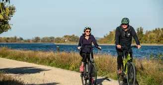
ViaRhôna Ardèche
Serrières > Pont-Saint-Esprit
65 Rue des Écoles
07340 SerrièresRond-Point de l'Europe
30130 Pont-Saint-EspritA veritable Ariadne's thread, the ViaRhôna is an invitation to discover the rich and varied heritage bequeathed to us by the civilizations that have succeeded one another along the Rhône.
We invite you to discover the historic cities of Tournon, La Voulte-sur-Rhône, Viviers and Bourg-Saint-Andéol, the characterful villages of Beauchastel, Rochemaure and Saint-Montan, the Romanesque jewels of Vion and Cruas, and the caves of Soyons. And let's not forget all the hillside vineyards that shape the Rhône Valley, with the evocative names of Condrieu, Saint-Joseph, Cornas and Saint-Péray.
It's also an opportunity to take in some exceptional engineering structures, such as the first historic suspension bridges in northern Ardèche, or the two Himalayan footbridges created for the ViaRhôna, reusing the piers of the 280m-long Vieux Pont at Rochemaure.
In Ardèche, ViaRhôna is full of nature. It slaloms between canals, small streams, vineyards and orchards. The ViaRhôna is a veritable backbone for gentle travel, linking up with other soft paths and irrigating the heart of our valleys. With the Voie Bleue, the Dolce Via, the voie douce de la Payre and, very soon, the Via Fluvia, there are so many new ways to discover and enjoy the region.
On your bikes!
Your contact
Agence Développement Touristique de l'ArdèchePôle Bésignoles, 6 Rte des Mines, 07000 Privas
07000 Privas
Find this route on the Loopi mobile app
Scan the QR code, save it as a favorite, or start the guidance, just enjoy!
Scan the QR code, save it as a favorite, or start the guidance, just enjoy!
On the itinerary
Route development
29% shared roads
70% cycle paths
87% cycle routes
59% greenways
Road surfaces
135 km on asphalt or tarred road
34.5 km on unknown surface in the Open Street Map database
6.89 km on rolling path (compacted sand, gravel, cobblestones)
This route is provided by: Agence de Développement Touristique de l'Ardèche
Be cautious and prepared during your outings. Loopi and the author of this sheet cannot be held responsible for any problems that occur on this route.


