The Dolce Via from La Voulte sur Rhône to Saint-Agrève
La Voulte-sur-Rhône > Saint-Agrève
© ©ARG-ADT07

© ©ARG-ADT07

© ©ARG-ADT07

© ©EW-ADT07

Place Étienne Jargeat
07800 La Voulte-sur-Rhône
Departure altitude: 94 m
150 Place de la Gare
07320 Saint-Agrève
Arrival altitude: 1053 m
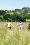
The Dolce Via is a gentle trail in Ardèche taking you all the way to the banks of the Eyrieux River and its well-preserved valley. 90 km of safe softway in the Eyrieux valley with stunning views !
The Dolce Via follows the route of an old local railway abandoned since 1968, and now provides a completely safe route from La Voulte-sur-Rhône to Le Cheylard, then Le Cheylard to Saint-Agrève and from Le Cheylard to Lamastre. This trail is reachable from several places and is perfect to discover the inland of Ardèche by bike.
An invitation for ramblers to discover the countryside and its wild scents amongst green oaks, boxwoods and acacias, the many works of art, and to understand the agricultural and industrial past of this valley.
Cycling with family, friends or for time out by yourself, enjoy picture-postcard landscapes and fresh, country air. Along the way are opportunities to have lunch on a restaurant terrace, relax at a shady café or picnic in the rocks. You can even hire a canoe at Eyrieux Sport or fancy rock climbing above the river at Aquarock!
Worth knowing: the trail is very easy when starting from Saint-Agrève to La Voulte-sur-Rhône (going downhill).
Alternatively, start your ride on board the steam train ‘Train de l’Ardèche’ from Saint-Jean-de-Muzols to Lamastre where the Dolce Via starts. Advanced bookings for cycles on board compulsory.
Your contact
Agence Développement Touristique de l'ArdèchePôle Bésignoles, 6 Rte des Mines, 07000 Privas
07000 Privas
On the itinerary


Positive elevation (ascent): 2094 m
Negative elevation (descent): 1141 m
Route development
4% shared roads
95% cycle paths
99% cycle routes
95% greenways
Road surfaces
22.6 km on asphalt or tarred road
7.98 km on unknown surface in the Open Street Map database
27.4 km on rolling path (compacted sand, gravel, cobblestones)
14.3 km on trail and off-road track
Find this route on the Loopi mobile app
Scan the QR code, save it as a favorite, or start the guidance, just enjoy!


Scan the QR code, save it as a favorite, or start the guidance, just enjoy!
This route is provided by: Agence de Développement Touristique de l'Ardèche
Be cautious and prepared during your outings. Loopi and the author of this sheet cannot be held responsible for any problems that occur on this route.