L' Échappée volcanique
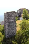
Saint-Jean-le-Centenier
© Gûlwen Heide - Barbara Jarjat

© ©C.Rochette-OT_Berg_et_coiron-ADT07

© ©B.Jarjat-OT_Berg_et_coiron-ADT07

© ©ARG-ADT07

© Gûlwen Heide - Barbara Jarjat

© Gûlwen Heide - Barbara Jarjat

© Gûlwen Heide - Barbara Jarjat

© ©C.Rochette-OT_Berg_et_coiron-ADT07

15 Place de la Mairie
07580 Saint-Jean-le-Centenier
Departure altitude: 339 m
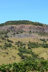
This bike loop runs along the majestic basalt organs of the Coiron volcano, in Ardèche.
ATTENTION MARKING IN PROGRESS
This picturesque adventure will take you through authentic villages: St Jean le Centenier, Lussas, the characterful village of Saint-Laurent-sous-Coiron, Darbres and Mirabel.
Immerse yourself in the geological history of the region while enjoying breathtaking panoramas.
Shortly after departure, take a detour by the Pradel to visit the Domaine d'Olivier de Serres!
Stop to enjoy the panorama from the belvedere of St Laurent under Coiron, also in Mirabel or finish at Jarnias.
An unforgettable experience for cycling enthusiasts and nature lovers!
Your contact
Agence Développement Touristique de l'ArdèchePôle Bésignoles, 6 Rte des Mines, 07000 Privas
07000 Privas
On the itinerary


Positive elevation (ascent): 864 m
Negative elevation (descent): 867 m
Route development
99% shared roads
Road surfaces
16.5 km on asphalt or tarred road
20.6 km on unknown surface in the Open Street Map database
Find this route on the Loopi mobile app
Scan the QR code, save it as a favorite, or start the guidance, just enjoy!


Scan the QR code, save it as a favorite, or start the guidance, just enjoy!
This route is provided by: Office de Tourisme Berg et Coiron
Be cautious and prepared during your outings. Loopi and the author of this sheet cannot be held responsible for any problems that occur on this route.