Riding in the heart of the Ardèche
Privas
© ©AL-ADT07

© ©L.Clara-ADT07

© ©A.Renaud-Goud-ADT07

© ©A.Renaud-Goud-ADT07

© ©ARG-ADT07

Rue de Bir Hakeim
07000 Privas
Departure altitude: 302 m
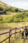
Leaving Privas, you'll take to the heights along the Route des Dragonnades, to enjoy the Eyrieux and Rhône valleys.
After a 15km climb to the Boutières region, you'll be able to admire magnificent panoramic views of the Ardèche mountains, the Rhône valley, the Vercors and beyond. Then descend to the Eyrieux valley. Enjoy the gentle Dolce Via.
Joining La Voulte, the ViaRhôna awaits you to take you along the Rhône to Le Pouzin. From there, you'll head back up to Privas via the Payre valley, following the route of the old railroad line, with its many tunnels, viaducts, bridges, footbridges and hydraulic structures...
Special difficulties
Quelques forts % de pente (10-12%) entre Privas et Pranles.
Your contact
Agence Développement Touristique de l'ArdèchePôle Bésignoles, 6 Rte des Mines, 07000 Privas
07000 Privas
On the itinerary


Positive elevation (ascent): 1178 m
Negative elevation (descent): 1178 m
Route development
47% shared roads
52% cycle paths
56% cycle routes
50% greenways
Road surfaces
42.0 km on asphalt or tarred road
32.3 km on unknown surface in the Open Street Map database
13.5 km on rolling path (compacted sand, gravel, cobblestones)
212 m on trail and off-road track
Find this route on the Loopi mobile app
Scan the QR code, save it as a favorite, or start the guidance, just enjoy!


Scan the QR code, save it as a favorite, or start the guidance, just enjoy!
This route is provided by: Agence de Développement Touristique de l'Ardèche
Be cautious and prepared during your outings. Loopi and the author of this sheet cannot be held responsible for any problems that occur on this route.