Rolling hills steeped in history
Alboussière
© ©ARG-ADT07

© ©ARG-ADT07

© ©ARG-ADT07

© ©ARG-ADT07

© ©ARG-ADT07

© ©ARG-ADT07

© ©ARG-ADT07

© ©M.Bourdin-ADT07-autour_de_Saint-Sylvestre-cyclo

Impasse des Pauvres
07440 Alboussière
Departure altitude: 553 m
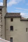
Leaving Alboussière and the Ardéchoise roads, you reach Champis. You'll arrive at Boffres and its perched village with 360-degree views.
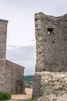
You'll pass the remains of an ancient feudal castle, then several châteaux and town houses that will delight heritage enthusiasts! You'll end up under the majestic gaze of the Church of Saint Didier de Crussol.
Your contact
Agence Développement Touristique de l'ArdèchePôle Bésignoles, 6 Rte des Mines, 07000 Privas
07000 Privas
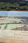
On the itinerary


Positive elevation (ascent): 864 m
Negative elevation (descent): 859 m
Route development
99% shared roads
Road surfaces
29.6 km on asphalt or tarred road
10.3 km on unknown surface in the Open Street Map database
187 m on trail and off-road track
Find this route on the Loopi mobile app
Scan the QR code, save it as a favorite, or start the guidance, just enjoy!


Scan the QR code, save it as a favorite, or start the guidance, just enjoy!
This route is provided by: Agence de Développement Touristique de l'Ardèche
Be cautious and prepared during your outings. Loopi and the author of this sheet cannot be held responsible for any problems that occur on this route.