The Cévenole crossing
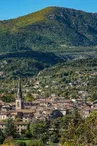
La Bastide-Puylaurent
© ©R.Pellet-OT.Cevennes-d-ardeche

© ©R.Pellet-OT.Cevennes-d-ardeche

© ©M.Dupont-ADT07

© ©R.Pellet-OT.Cevennes-d-ardeche

© ©R.Pellet-OT.Cevennes-d-ardeche

© ©R.Pellet-OT.Cevennes-d-ardeche

Place de la Gare
48250 La Bastide-Puylaurent
Departure altitude: 1022 m
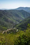
Not far from the Trappist convent of Notre-Dame des Neiges, head for Montselgues and its granite chaos, les boules de Gargantua. From there, you'll plunge through woods alternating between coniferous and chestnut trees to reach Les Vans. Between holm oaks, cades, vines and almond trees, here schist sets the tone. Then comes Malbosc, with its lauze roofs, steep slopes and man-made faïsses. You're right in the heart of the Cévennes ardéchoises.
The route links the stations of La Bastide-Puylaurent (48) and Génolhac (30) in 3 Ardèche stages, passing through Montselgues, Les Vans and Malbosc before reaching Génolhac.
Total length of route: 133 Km (99km by bike from La Bastide-Puylaurent to Génolhac + 34km by train from Génolhac to La Bastide-Puylaurent)
Total ascent: 3,540m including 2,170m by bike
Main entry/exit points: La Bastide-Puylaurent / Montselgues / Les Vans / Malbosc / Génolhac
By bike: 99km from La Bastide-Puylaurent to Génolhac
By train: 33km from Génolhac to La Bastide-Puylaurent
Stage 1: La Bastide-Puylaurent - Montselgues
25km / D+ 680m / D- 680m / Alti max 1083m / Alti mini 567m / Difficult
Leaving La Bastide, you'll pass by the Palet de Gargantua, a huge sandstone slab that suggests it may have been a dolmen. Then, without forcing your way through the woods, you'll reach the Beaumes chapel. From here, the road rises over this magnificent valley, with a 15% gradient to reach the hamlet of Pradons and on to Montselgues.
Stage 2: Montselgues - Les Vans
32.6km / D+ 300m / D- 1,140m / Alti max 1,020 / Alti mini 140m / Average
Head for the Col de l'Echelette to reach the corniche of the Vivarais cévenol and its highly contrasting landscapes. The breaks in slope are so abrupt that you don't just descend from the plateau, you fall off it. Leaving the magnificent Thines valley on your right, and the magic of its perched village, you plunge through woods alternating coniferous and chestnut trees, punctuated by a few clearings and dotted with small hamlets of old stone houses with slate roofs, to reach Les Vans.
Stage 3: Les Vans - Génolhac
41.4km / D+ 1,170m / D- 700m / Alti max 620m / Alti mini 180m / Difficult
Leaving Les Vans, holm oaks, almond trees, vines and cades announce Mediterranean vegetation. The countless "accols", terraces held back by low dry-stone walls, and "clapas", scree slopes that bear witness to the past, when peasants, in order to find a little arable land, had to relentlessly remove stones from their plots by hand.
Your contact
Agence Développement Touristique de l'ArdèchePôle Bésignoles, 6 Rte des Mines, 07000 Privas
07000 Privas
On the itinerary
Positive elevation (ascent): 3577 m
Negative elevation (descent): 3570 m
Route development
93% shared roads
6% cycle paths
1% cycle routes
0.05% greenways
Road surfaces
28.0 km on asphalt or tarred road
146 km on unknown surface in the Open Street Map database
2.40 km on rolling path (compacted sand, gravel, cobblestones)
265 m on trail and off-road track
Find this route on the Loopi mobile app
Scan the QR code, save it as a favorite, or start the guidance, just enjoy!


Scan the QR code, save it as a favorite, or start the guidance, just enjoy!
This route is provided by: Agence de Développement Touristique de l'Ardèche
Be cautious and prepared during your outings. Loopi and the author of this sheet cannot be held responsible for any problems that occur on this route.